
Postcard from... the A65
/
Words: JP Robinson
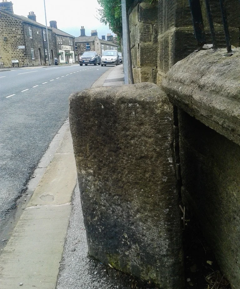
Not far from where I live, opposite a builders’ merchant and a private day nursery on the A65, there is a two-foot tall, cut and dressed gritstone prism, next to the front garden wall of a terraced house. On its triangular top, there are three carved, circular cups, each just a few inches across. The prism occupies two thirds of a narrow pavement, and it enjoys special protection as a prehistoric scheduled monument under the Ancient Monuments and Archaeological Areas Act 1979. Although it is sometimes known as a milestone or waymarker, very little is known about it, and there is no plaque or signage. Drivers rarely notice it and, without breaking conversation, young families wheel their pushchairs on to the road to get past, on their way to the Tesco Express or Costa or play centre over the level crossing nearby.
Monuments like this are odd, of course, but surprisingly commonplace. There are over 10,000 prehistoric scheduled monuments in England: barrows and tumuli, stone circles, ancient pathways and carved stones. This compares to around 1300 A roads: multi-lane highways, suburban shopping streets, irregular cross-country routes and modern access roads for out of town industrial complexes. Numerically at least, a prehistoric monument is about seven and a half times more common than an A road.
The A65, which runs next to the prism, starts in Leeds and tracks the river, the canal and the railway, north and west out of the city. It passes industrial units at first, and back to backs, and the ruins of Kirkstall Abbey. At one time, it ran directly through the abbey nave, but it now just separates the main abbey buildings from their gatehouse. There is a stone in the grounds, carved with prehistoric cups and grooves. As the road leaves the city, it passes more cup stone carvings, high on a famous outcrop near Ilkley, and the earthworks and Round Dikes on the moor. The road continues, skirting the Dales and the Moors, past a circular enclosure, into Lancashire and, officially, the A65 ends as it crosses the M6, sixty five miles from Leeds.
On a map, A roads suggest something - cutting from town to city, circling larger settlements - but there appears to be little order, without their numbers. The numbers form spiralling, concentric, circular patterns, similar to the carved prehistoric markings, or the alignments of stones and mounds and ditches. Although many of the roads are ancient themselves, the numbering system was designed in the mid-fifties, and has been added to since. Developing on a system that had been used since before the First World War, a committee of men at the Ministry of Transport divided England and Wales into six sections, and Scotland into three. They numbered the English and Welsh sections clockwise, centred on London. The eight single-digit A roads formed the boundaries to the sections, and the names of the zones came from the road on its highest numbered border. Zone 6, the largest section, is bordered by the A6 in the west, and the A1 in the east, and extends from London to the Scotland.
In each zone, the double-digit roads were then numbered sequentially, and clockwise: the A60 is the first double-digit A road clockwise from the A6, the A61 is the next. If a road crosses into another zone, its number comes from the furthest anti-clockwise zone it enters. The triple and quadruple digit roads, and the B roads, were numbered next, according to their distance from London, rippling out from the capital. The spokes of the single and double-digit roads are patterned with radiating triple and quadruple digit numbers. Originally, the double-digit roads were more significant than the triple and quadruple digits, though the plan has been eroded gradually, as roads have been rebuilt or repurposed.
The numbering system creates an obscure pattern, either too large in scale or too humdrum to make out easily. Like many large, humdrum things, and like the prehistoric monuments that the roads pass, the pattern reveals something ineffable about the society that created it, this society that numbers the streets where its children walk, making unnecessary patterns across the land, orbiting its larger settlements, a society that affords special status to certain roads and certain stones, carved for long forgotten reasons.